Feeds:
Posts
Comments

Archive for the ‘Petrolia’s Downtown’ Category

A couple of years ago, the Mattole Valley Historical Society received this letter:

D&ML,Rudolph,01-coverletter,crop

I mentioned the intriguing find in one of ourĀ Now… and ThenĀ newsletters, but I don’t think I had shared any of the photos publicly. Now that we have gotten good information to augment the pictures from a Rudolph descendant, Carolyn “Corky” Peterson of Fresno, it’s high time we showed off some of the pictures.

The Rudolph family itself merits a stand-alone post, but that’s something for another day. Briefly, the story is that three of the Rudolph siblings, children of Mary Hamblin and John Caspar Rudolph–born in the late 1700s in Austria–made their way to the Mattole Valley in the 1860s. The three were brothers John C., Morgan, and Thomas. John had the Petrolia Store, of which you have probably seen pictures; Morgan was a preacher throughout the Mattole Valley; and Thomas made his way to Upper Mattole before Honeydew was named. He homesteaded land, in 1889, at the foot of Woods Creek in Sections 2 and 11 of T3S, R1W, which was later owned by James Ballard, then later by Hunter (presumably Ballard’s brother-in-law, Judge G.W. Hunter)–in case you want to locate where, possibly, this family lived.

The Mattole Valley Historical Society has enjoyed the attention and membership of many descendants of these original three Rudolphs. Many of the Clarks, Hunters, Rackliffs (including Mary Rackliff Etter), and Wrights of recent history or current residence are descended from Morgan Rudolph, via his daughter Martha, who married Marshall Wright. Conrad Rudolph, a professor of medieval art history at UC Riverside, is a direct descendant of John Rudolph. And most valuable to identification of this photo collection, Corky Peterson is the granddaughter of Gwyneth Rudolph, who was herself the granddaughter of Thomas and Martha Coy Rudolph via William Rudolph and his wife, Caroline Langdon (a sister of Mrs. Charles Johnston and Mrs. Isaac Dougherty). So you can see that although the Rudolphs all departed the Mattole Valley by the first decade of the 1900s, they left their marks as prominent and influential citizens. In fact, Emma Rudolph, a daughter of Morgan and Rebecca Rudolph, kept a diary as a 15-year-old girl living in downtown Petrolia. The 1882 document would be another fascinating read on this blog, so stay tuned!

According to Corky, the photo albums are of the Thomas>William H. and Caroline>Gwyneth line–her grandmother’s family. Although many of the pictures (and most that I will post here) are, I believe, from the Mattole Valley, the family spread far, geographically; two of William’s sisters, Corky’s great-great aunts, married two Langlois brothers. The Langloises, for whom the town in Oregon just north of Port Orford is named, settled in the area from Coos Bay to Bandon to Port Orford–the Cape Blanco lighthouse (further west even than Cape Mendocino’s) being the residence of keeper James Langlois, along with wife Elizabeth Rudolph and at least five children, for 42 years. But Gwyneth herself retired to Marin County; she lived there with her daughter Norma, who was Corky’s aunt. That’s probably how the albums came to be found in Greenbrae, California.

D&ML,Rud.,24,picnic,crop
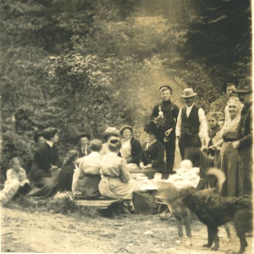
Corky and I think this picnic may be a Johnston family affair, the man about 4th from left resembling other photos of Charles A. Johnston; Mr. Johnston was married to Corky’s great-grandmother Caroline Langdon Rudolph’s sister Evaline.


D&ML,Rud.,13

Looks like a gulch of the lower Mattole Valley. (Maybe she is considering a hike up that little canyon, and a change of clothing.)


D&ML,Rud.,03,ladies,treeplant

Possibly sisters Eveline and Caroline, ca. 1890, according to Corky. However, comparing with the photo of three sisters down this page a little, I think it might be daughters of Caroline: Nettie (older, left) and Alda (full name Martha Alda, younger)… photo perhaps taken by their middle sister, Gwyneth. Hand-held camera snapshot suggests the twentieth century.


D&ML,Rud.,15

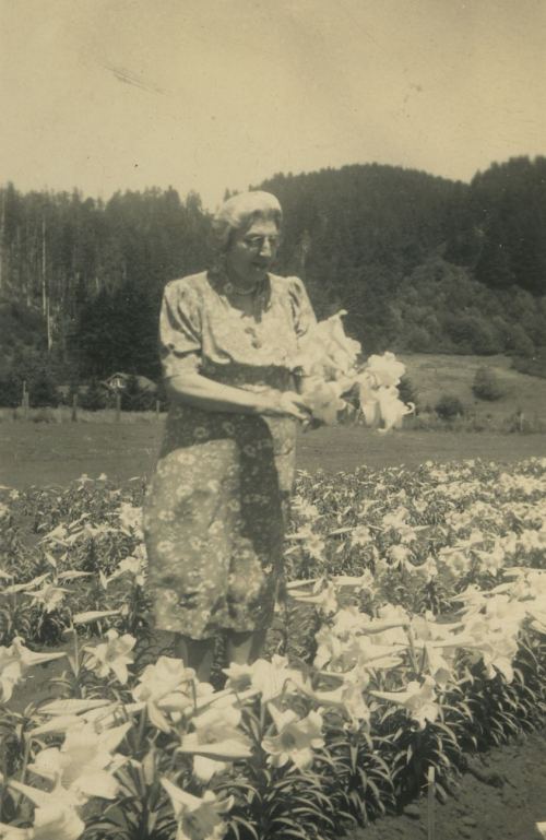
This is more recent, given the length of the lady’s dress. Tending the lilies.


D&ML,Rud.,05,Oilwell

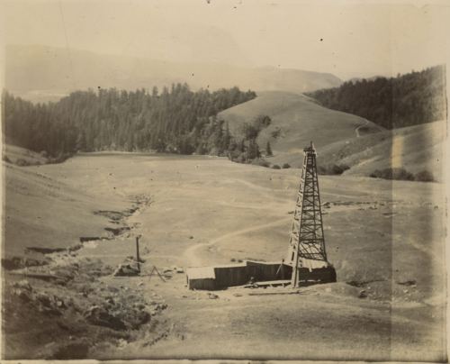
Possibly the Joel Flat (sometimes called Henderson) oil well, which has also been captioned, in a Mary Rackliff Etter photo, the McIntosh well. If it is indeed that one, it would make sense to be seeing the Mattole Valley behind, to the south of it, heading westward/right to the ocean.


D&ML,Rud.,09,oilrigs,wPlume

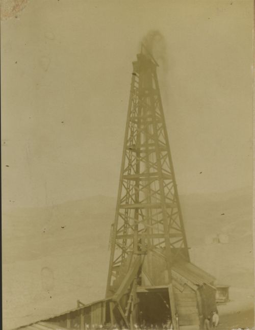
Same well. Note the small figures of men in the lower right. Looks like a plume of–what, oil vapor or froth coming off it?


D&ML,Rud.,04,man,onDisstonSign

Photo taken at unknown location, possibly Humboldt County. The man (unidentified, probably a friend of Grandmother Gwyneth’s) is sitting over a metal sign advertising Disston Saws for the California Saw Works–San Francisco, Seattle, Portland. An online search (you can find the signs on eBay) tells me that the signs were manufactured from 1901-1905 by Meek and Beach Co. I suspect the gate might be on land logged by a company contracted to California Saw Works.


D&ML,Rud.,22,John,calledJack,Tyler

Corky’s father, John (Jr., called Jack) Tyler, son of Gwyneth Rudolph Tyler. He was born in 1906; photo probably from about 1912 (when little boys were not pushed to dress in a manly fashion).


D&ML,Rud.,32-Gwyneth,Nettie,1887,Bandon

Gwyneth, mother of little Jack from the photo above, on the left; with her big sister Nettie, probably from around 1887 (when little girls needn’t have girly hairstyles).


D&ML,Rud.,41,sistersAlda,Nettie,Gwyneth

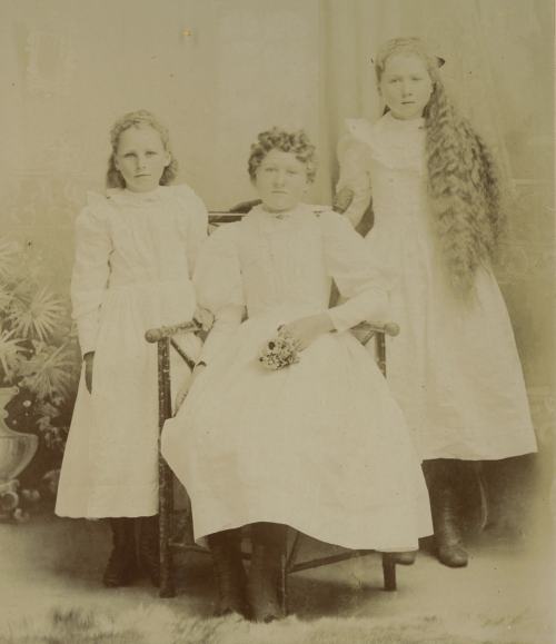
About nine years later, the three daughters of William Rudolph and Caroline Langdon: Alda, Nettie, and Gwyneth.


D&ML,Rud.,14,Petrolia,frE,dark

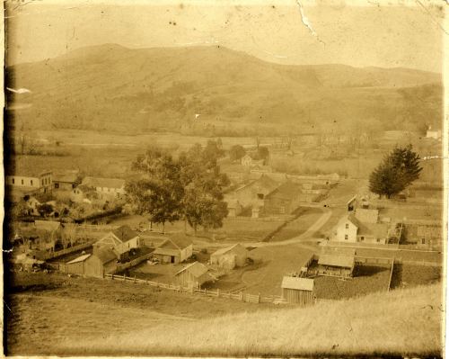
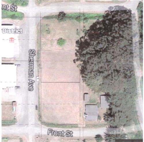
Petrolia from the hill to the east-northeast of the Square. Taken sometime before the 1903 fire. Several of the buildings still stand: you can see Ocean Berg’s (once Jim Groeling’s, a long time back the Watson-Cady house); Mary Day’s (once Lucy Wright and Elias Hunter’s); Swaffords’ (once Jack and Vivian Susan Wright’s, called Briarcrest); the Leonard Cook (Mayme Hunter’s) house on the southeast corner of the Square; and various sheds and barns that have survived. The old Knights of Pythias hall, site of the future MVHS museum, is on the Square, along with, to the south/left, the original hotel; the John Mackey store, and other buildings that burned down, are on Front St., along the far left. On the hill behind the North Fork valley, you can see a house, about a third of the way from the left of the photo. Is that one of the old Clark family places?
Below, a crop showing a tiny bit more detail:

D&ML,Rud.,14,Petrolia,frE,dark,crop


~~~~~~~~~~~~~~~~~~~~~~~~~~

That’s all for now. We are very grateful to the Landgrafs of San Rafael, without whom we would never have seen these beautiful pictures… and to the internet, without which they may not have found us.

D&ML,Rud.,02-Album1coverThe ragged cover of one of the albums.

Read Full Post »

In case you haven’t heard, the Mattole Valley Historical Society has been made the generous offer of a good-sized spot of land on the Petrolia Square for the purpose of building a fireproof place to house our archives. We will also have a space large enough to start collecting and displaying all manner of artifacts… much more than what we can do at the Grange location, which is really just our office and library. In other words, we will be able to have a museum, once we have a building–and now we have been offered the site. Here is a view from Google Earth that shows, on the northwest corner of the Square in downtown Petrolia, the three-parcels-in-one that make up our future home. That’s the Petrolia Store on the left, below the Petrolia VFD firehouse and just across the road from the lower property line.

4-GoogleAir-view, site, crop

And here is the latest of a series of floor plans for the 40 x 24-foot building we (the Board) have been envisioning (note that i am not a professional architect or artist, and these are just preliminary homegrown sketches):

2-4thFloorPlan,June2016

The museum building would be on the northernmost of the three formerly separate parcels–that is, on the northwest corner of the Square, sitting where the Knights of Pythias Hall used to be.

I have written many pages about the excitement of this promise, and also many words imploring any likely candidates in the areas of grant-writing, fund-raising, project direction, and building planning and permitting, to step forward. Mainly because of the offer, we now have an invigorated and legally functional Board of Directors. But we do need another couple of key players to get this project off the ground.

We would like to be able to pay at least one person (the Project Director) who would then be able to make the time to focus on overseeing the project. I assure you though, the money would not be the main attraction. One of the first jobs of an active push toward this vision will be to write a grant to pay the Director! So, if making a big pile of cash is anyone’s goal, this would not be a position to apply for. However, we do feel that the effort that will be required to gather our energy, time, and money and convert it into some version of a Mattole Valley historical museum in downtown Petrolia, ought to be reimbursed with a helpful stipend. So, by all means, if you are interested in working with us, please get in touch with us–contact info at end of post.

Did i mention that i will be stepping down as Director of the MVHS come December? Yes, i’ve given my several-month notice to the Board. There was too much fuzziness about who does what, and we have a lot to do. I intend to keep studying history, doing research and interviews, and writing about the Mattole Valley’s past. But i do not mean to carry on with the business of running the organization. So we will be needing a Director of the Society as 2017 rolls around;Ā  you will be working with a cooperative Board, a competent and thorough Secretary and a great Treasurer. For now, though, we are in dire need of a Project Director and a Grantwriter for the development on the Square.

Opportunities abound!

But let me leave you with these grand visions. Of course we don’t need an all-or-nothing attitude about anything as huge (relatively speaking) as this floor plan, and we don’t need to be discouraged if it’s slow going toward an entire compound such as that depicted in the site plan below. We could certainly start our fireproof lodging of materials on the site if we could get the 10 x 12-foot shed built; or, as was just suggested to me today, we might throw up the metal building on the south end meant to be a rougher home for agricultural and industrial equipment–an easily fire-proof structure–and store everything in there, with a big sign saying “Excuse the mess! Museum building in progress,” while we work on the more homelike museum and office building.

But here are my sketches of one idea of how the site might be laid out… and my primitive drawing of a renewed and revitalized corner of the Petrolia Square. (The parking lot is just a suggestion of how cars might be able to park… we wouldn’t need that many spaces, and only the A.D.A. (handicapped) spots need to be paved… so don’t worry, we won’t Pave Paradise to put up a parking lot. More grass, native plantings, and art or outdoor equipment displays would be better. Probably most parking could be along the road around the Square.)

3-SitePlan,rough,May2016,sfw

1-BuildingOnSite,color,fixedParking

Please get in touch with us if you want to help make this a reality, or if you know of anyone we might tap. There are a lot of new people in the Valley lately… maybe someone would like to become an instant essential citizen, by jumping into this niche. E-mail mattolehistory@frontiernet.net, call 707-601-7300, or comment here and we will contact you! Thank you!


Read Full Post »

As i was wandering the Humboldt State University online archive of historical Humboldt County photos, i ran across a few gems. (There are thousands of jewels there, of course, but as a Mattole history fan, these in particular set my heart a-flutter!) Many thanks to Joan Berman, who is responsible for the archive and who maintains the website. What a huge labor it must have been to organize all these images, and to keep the collection updated!

I am posting smaller files of the pictures here (though you can click on them to magnify); for full resolution and to enjoy the myriad treasures available there, view them on the HSU website.

A camp in the Mattole Valley, photograph by A. A. Burgess. Probably taken before 1900.

A camp in the Mattole Valley, photograph by A. A. Burgess. Probably taken before 1900.

Here’s how: go to this link: http://library.humboldt.edu/humco/holdings/photosearch.php and in the lower right box, “Photographer,” scroll down to “Austin Burgess” and you will get to the list of ten of his photographs in the Peter Palmquist collection. The wonderful, painterly photograph above is #2 on the list. The men on the left look familiar from our MVHS archives; could the one next to the horse be Charles A. Johnston?
The MVHS already has copies of most of these Burgess photos, and several are on this West of the Redwoods site already, but a few were new to me. This one below (#3 on the Burgess list), of women and children sitting on the beach, seems to be of a Native, or part-Native family. One of the women on the right looks like a Hadley family member. Note the daring individuals atop, and just below, a precariously-perched boulder in the background.
Women and Children Sit on Rocks at Beach, by A.A. Burgess.

Women and Children Sit on Rocks at Beach, by A.A. Burgess.

And this next one also offers great detail. The photo is #1 on the Burgess list on the HSU page. I don’t know who the men are, but think maybe the man just visible behind the horses, taking care of some strap or cargo, is also Native.

Men Gathered around Horse-pulled Wagon Stopped on Road next to Barn, by A.A. Burgess

Men Gathered around Horse-pulled Wagon Stopped on Road next to Barn, by A.A. Burgess.

Peter Palmquist collected these photos and labelled them based on either “official” titles attached somewhere along the way, or on clues he gathered from the pictures or descriptions written on the reverse. Some of the pictures have two titles: one credited to the collector [pp], the other i assume a description from the current archivist, Joan Berman. So, the titles are not always accurate. This school is supposed to be in the Mattole Valley, probably because so many of Burgess’s scenes were; but i am not sure it is. It may be at Capetown or up Bear River. Comparisons to photos of the old Mattole Union School, Union Mattole, Upper Mattole, or Honeydew School show this to be a much smaller building. (I definitely could be wrong about this; anyone with any conviction about which school this is, please comment.) I love the outlaw kids on the roof, though–classic “out in the hills” stuff!

Children and Teacher Gather at Schoolhouse in Mattole, by A.A. Burgess

Children and Teacher Gather at Schoolhouse in Mattole (?), by A.A. Burgess.

A little background information about Ammi Austin Burgess: he was Gypsy Evenden’s, and current MVHS friends Roger and William Brown’s, great-grandfather. He was born in 1842 in Maine, served in the Union Army from April 20, 1861 (enlisted in Waterville, ME)–April 20, 1864 (honorably discharged at Brandy Station, VA), was in Santa Cruz County by 1871, and in 1877 married Elizabeth A. (from New Hampshire, of unknown maiden name)–Lizzie Burgess. By 1879 the couple had their daughter, Maude Addie, and in 1882, son Wallace D. Burgess–Gypsy and the Brown boys’ (great)-uncle Wally. According to Gypsy, “Ammi” always detested his given name, thinking it sounded too feminine, and went by either his initials or his middle name. A.A. and Lizzie lived in the Petrolia area, with Mr. Burgess listing his occupation as “farmer”–but meantime he had mastered the art of studio and landscape photography, and likely took most of his photos in the last quarter of the 19th century.

 
I called Roger Brown the other day to tap his memories. He never knew A.A., who died in 1906 at a southern California Veterans’ Hospital; nor was Roger sure where exactly he’d lived in the Mattole Valley. However, A.A.’s two children later lived on the south side of the river across from the present Cockburn (former Molly Roberts West) place. Uncle Wally had the place right next to the river where newcomers (now gone) Sean and Becca recently established a small homestead. Maude Addie lived with her husband, Samuel F. (Frank) Adams, across the road and a bit east. The home was just up off the flat we used to call “the Reishus place” which was an opening with an old pile of bricks on it, and later Frankie Lawrence’s trailer, until recently cleared for use by Sterling McWhorter.

[A tiny bit of genealogy to fill you in on the rest of the connection: A.A. and Lizzie Burgess’s daughter Maude married Frank Adams, the son of Samuel S. Adams and Annie Brown, who was herself the daughter of famous abolitionist John Brown. So Maude and Frank were Roger’s (and William’s and Gypsy’s) grandparents. Their children included Louis Adams, father of Gypsy, and Alice Adams Brown, mother of the Brown brothers. Alice was born in the house above the old Reishus flat. And Wallace D. Burgess married Edna Williams of Ferndale in 1905. Wally was an engineer for the Northwestern Pacific railroad.]

A.A. Burgess’s photos not only function as valuable historical records of people and places, they are beautiful. There is one photo he took of three deer carcasses hanging in a row (doesn’t sound pretty, but it was– and i as a vegetarian assure you of that!). Gypsy gave us a print of the photo, and also once showed me a wonderful pencil rendering of the photograph, which she knew was done by Wallace D. Burgess. I always thought that Wally must have been the “Burgess” photographer too, but no, it turns out he was a sketch and painting artist. Roger said he “knew Uncle Wally real well. He had a little coupe, and i remember him sitting in the back of that car, with an easel, sketching.” Roger has a charcoal of the St. Paul aground near Punta Gorda, and another painting of the Petrolia area from the vantage point of the hill west of town, done by his great-uncle–perhaps while sitting in his car.

By the time Austin Burgess made it to the Veteran’s Hospital in early November, 1906, he was suffering from Pulmonary Tuberculosis, something else i couldn’t make out, Chronic Inflammation, and Deafness. He succumbed to his many ailments on the 20th of that month. Veteran’s benefits began coming to his widow Lizzie in Ferndale. She passed on to join her husband in December, 1916.

I am grateful to Ammi Austin Burgess for his loving and careful artist’s eye and his photographic skills, and to the late Peter Palmquist, the HSU library, and Joan Berman, for preserving the images and making them available to us.

But before you go away, i want to share one more picture. I am currently unable to download this image, but took a screenshot. This is an unusual photograph of Petrolia, taken before 1903 (when a fire destroyed many downtown buildings), from the hill to the east: just a bit north of the present Catholic Church, behind Cary’s house. I love a new picture of old Petrolia, especially one from this early a date!

View of the town of Petrolia in the valley of the surrounding hills, by William Wax.

View of the town of Petrolia in the valley of the surrounding hills, by William Wax.

Do you recognize any of the buildings? Not many remain. You’re looking over the square, toward the ocean. There’s a white frame house where the Franklins’ place is now. Mary Day’s house is in place. On the far right, there’s a little church which was the predecessor of today’s Seventh-Day Adventist Church building, on the same site. The large white buildingĀ  on the left, with four windows in a row along its side, was the two-storey John A. Mackey store and ballroom.

The picture is from the Peter Palmquist collection, and can be seen in excellent detail here: http://library.humboldt.edu/humco/holdings/photodetail.php?S=&CS=All%20Collections&RS=ALL%20Regions&PS=Wax%20William&ST=ALL%20words&SW=&C=26&R=13

Photographer was William Wax, about whom i know nothing. Googling shows that a William Wax was active in the photography businesses of Columbia, CA (in the Sierra foothills) and the Chico/Redding areas. Perhaps he travelled with his photographic equipment, and luckily for us, passed through Petrolia one fine day.

Enjoy some winter hours enjoying the thousands of pictures available on that fantastic HSU site!

Read Full Post »

Note: i don’t have a category for “Photos” alone, since so many of these posts have a few. However, if you put “photos” in the Search bar above, you will see the blog entries that are basically just pictures– such as this one!

From an album given to us by Dayton Titus. This is only the second picture i’ve ever seen of the John A. Mackey store. It burned in 1903, so this is a very early photograph. Since the original was only about 2 inches in diameter, even this much detail in it (when blown up; to make it bigger, click on it, and click again…) is gratifying. The store was opposite the southwest corner of the Petrolia square.

Here’s another from the same page, same Titus album. I didn’t clean it up or Photoshop the scan in any way but to enhance the contrast… it was quite washed-out. But it’s a treasure, in that we only have two or three other views of this hotel, which was the one on the square. The structure must have been enlarged many times; i think this was the north wing, seen from the west; that is, it’s directly across from the present Petrolia Store. The main and original part of the hotel is to the right, on the southwest corner of the square.

A double exposure, probably accidental as nobody’s trying to look like they’re astride a horse; still, it does look like that one guy’s on a ghost horse, no? From the Titus album.

View northwest toward the hill at the end of Chambers Rd., which is the cliff above the narrow part of Conklin Creek Rd. There are a couple other pictures we have of this same view, from different times. This one shows a little more of the grazing area, perhaps giving more of a clue to the exact location of this enclosure. I believe it was between the curves of the road going down Shenanigan Ridge toward Petrolia, two turns below the present dump… land marked Mike Shallard on some of the very old maps. But i am not sure.

Old bridge not necessarily in the Mattole area (some of the pictures in Dayton Titus’s album are from Ferndale, maybe other places), but it could well be any of at least four in the lower Mattole (Honeydew and downstream) that cross between steeper, treed banks.

This picture was sent by Doris Long, the lady who knew the John W. and Florence Mackeys as a child. A nice view of the mouth of the river in 1941- ’42.

The story Doris Geib Long told, and several great pictures she sent, are here.

Lisa (Mrs. Laurence) Hindley sent these next few pictures. This is Joseph N.D. Hindley with a tamed fawn.

I can’t get my orientation right for this picture… are we looking upstream?

Another Hindley photo, of the structure for a straw barn at the family ranch in Honeydew.

Wind or lightning? Something felled this lone tree, but its regrowth is vigorous and beautiful. Thanks to Lisa Hindley for sending this and other photos.

Speaking of Hindleys, something tells me there might be some Hindley children in this group. Perhaps it’s a group of Honeydew schoolmates. The photo was in the Mary Rackliff Etter collection. I see some Native faces, and a few of the people strongly resemble those in other Honeydew group photos.

Jerry Rohde sent me this photo a couple of months ago. It is by A.A. Burgess, a Petrolia-area photographer, and it was filed with the Bear River-Petrolia pictures at the Humboldt Co. Historical Society. We are wondering if anybody knows where this apparently beachfront bachelor’s cabin was located. I sent it to John McAbery, wondering if he had any ideas about whether it might have been a previous structure on the location of his home at Four Mile Creek, but he said No. Anybody?

Well, many more photos upcoming when i find the time.

Read Full Post »

In my March 3, 2011, post called “More old buildings… ” i mentioned the story of the Mackey house that ended up on the site of the present Mattole Valley Community Center in Petrolia. (The photo is at the bottom of that article, too.) Martha Beer Roscoe had written an article in the Humboldt Historian, v. XVII, no. 4, about that house’s unique history. Please excuse the copy’s quality. You can read it if you click on it to enlarge. To clarify one point, across the street from it was what was called the Cavy Miner home. It was originally built by Cavy’s husband, Jacob Miner, but occupied by her and her brother-in-law, Cyrus Miner, for decades after. (It was Mrs. Alden Boots’s place in the late 1960s; she was Bill Selby’s mother.)

Thanks to the Humboldt County Historical Society, and to the late great
Martha B. (Mrs. Stanley) Roscoe.

Read Full Post »

In a recent post, “Treasures upon Earth,” i didn’t say much about the E.J. Etter place in Honeydew (i also mistakenly typed “Hunter” instead of “Etter,” but that’s fixed). However, i recently spoke with Miss Mary Etter, whose grandfather, Emil J. Etter, built that impressive house (he was the father of her and Mike Etter’s dad Charles). She told me that it stood very close to the house she lives in now, near the confluence of the Upper North Fork and mainstem Mattole, just north of the Honeydew bridge on the northeast side of the river. The building was so severely damaged in the 1992 earthquakes that she reluctantly had it dismantled. Miss Mary was surprised at what good shape it was still in (after about a century of earthquakes, winter rains, floods, and Honeydew heat).

E.J. Etter also, it turns out, built the Shinn home for his daughter, who became Mrs. Mary Shinn.

The Shinn Place, an inn located on what's now Alex Moore's property-- just a bit up Wilder Ridge Rd., southwest of the present school, near the site of the original Honeydew School. Photo courtesy Janice Peers Slack.

Miss Mary said this large building, close to the main road southward out of the Valley, was intended to help the Shinn family make a living. Janice Slack, whose mother, Verna Hawley Peers, taught at Honeydew in 1914-15, wrote that “Verna lived with the Shinn family in their large roadside inn where travelers would stay. There was a large stove on the first floor where men would congregate to talk and enjoy the warmth. When she wanted to take a bath, she would have to heat the water in a bucket on the kitchen stove and carry it upstairs to the bathroom, unavoidably passing the group. They would whisper and snicker, ‘The teacher’s taking a bath,’ which she tried to ignore as best she could. Returning to school after Christmas vacation, because of road conditions, she had to ride horseback from Ferndale to Honeydew.”

.

Coming back down the river, we find the old Frank X. Etter home still standing near Squaw Creek until quite recently:

Frank and Dora Hill Etter home, built on Squaw Creek-- about a mile up from its meeting with the Mattole-- in 1917. Photo from 1945.

This 1971 photo of the Squaw Creek home is from Brian Doyle, grandson of
Mr. and Mrs. F.X. Etter.

Francis X. Etter, born 1879, had married Dora Hill (daughter of Bertha Roscoe and George Russell Hill) and had four children already (Alma; Don, who just passed away in 2008 at almost 100 years old; Keith; and Edgar) when he built this house. Frances M., the youngest, was born in 1917, just as the house was finished. She married Brian Doyle, and our present MVHS member of the same name is their son.

In downtown Petrolia:

The hotel in Petrolia on the southwest corner of the square. Probably taken around 1900. From the Mary Rackliff Etter collection.


Charles A. Doe first ran a hotel here in 1869; various owners, managers, and renovations over the years kept it vital until the fire of April, 1903, destroyed it.

View east-southeast from the Lower North Fork to the Selby-Clemenza home on left, and the old Mackey place, later Maude Goff and Gib Langdon's, on the right.

This photo is cropped from a fantastically huge picture (17 megabyte jpeg file) from the Mary Rackliff Etter collection. The large white house on the right is the back of the building once sitting where the Community Center is today. I recently read an article by Martha Roscoe about the history of the house; i will copy it and post it in its entirety soon. The gist of it was that the structure was actually moved from the John Mackey property down near Mill Creek on Chambers Road to its Crane Hill location, where the Etter family bought it and leased it out to many families over the years. Gib Langdon and Maude Goff lived here, and newcomers Bill and Judy Johnston– he a 1950s Mattole schoolteacher and later telephone system owner and repairman, and she a charming and sexy lady, apparently, who caused more than a few wrinkles of anxiety in this staid Valley– occupied it when it burned down in the late 1960s.

One more note on the homes of the Petrolia area: Cindy Lyman commented on the “Treasures upon Earth” post that the Charles Johnston home strongly resembled the Selby house, visible to the left in the picture above, and one of the few nineteenth-century houses still standing in the Valley. I read an article today from the May 12, 1966, Ferndale Enterprise, by Mary Rackliff Etter, that explains the mystery: “The old home [the Lanini place, originally the Patrick Mackey home, which was just then being torn down] was erected some 80 years ago [1880s] by one of Humboldt County’s best known carpenters during that period of time. It was Charles Rackliff, who married Mary Clark, daughter of Mr. and Mrs. Charlie Clark, on Nov. 12, 1876. Other homes he so capably built in Petrolia were Mrs. (Aunt Cavie) Miner’s, later the Wm. Lytel home [Selby’s], and the Charlie Doe place up the North Fork, later the Rackliff home [pictured also in the “Treasures” post], which was located close to the present location of the Chambers home. Charlie Johnston’s home was also built by him plus five other homes which were built in a row just north of the Catholic Church, which included Mrs. Mary Dudley, Barney McDonna and the Goff home.”

I will have to look into that last-mentioned row of houses.

Charles Rackliff was Mary Rackliff Etter’s paternal grandfather; her mother Minnie Wright Rackliff’s brother C.E. (Jack) Wright was another well-known builder of the Petrolia area. Perhaps Jack learned much of his trade from his sister’s father-in-law.

Read Full Post »

“Lay not up for yourselves treasures upon earth, where moth and rust doth corrupt, and where thieves break through and steal: but lay up for yourselves treasures in heaven.”
~Matthew 6:19-20, King James Version

Some words of wisdom there. Of course, there are a few beautiful old houses from a hundred thirty years ago or more still standing in the Mattole Valley; but every time i get frustrated at my failures in getting my place together into an earthly paradise, i remember these old places, and how much time, sweat, and money went into building them, and how much living and loving went on in them. All gone. I hope they brought their people great joy– they were beautiful works.

Charles A. and Evaline Langdon Johnston home, built c. 1870, on site of present Cogswell home on Conklin Creek Rd. From the Humboldt Historian.

In center of photo, John Rudolph home, downtown Petrolia. Roughly on the site of present Gail and Phil Franklin home. 1888 photo from Mary Rackliff Etter collection.

The two images above are both of the Charles A. Doe home, on the Lower North Fork, a short distance above the present Mattole Road bridge. Charles and Mary Jane Clark Rackliff lived there after the Doe family moved to Ferndale. Top view is a pencil sketch from Elliott's 1882 History of Humboldt County; photograph is from Mary Rackliff Etter collection.

View showing location of Charles A. Doe home, on the lower reaches of the lower North Fork. If i’m not mistaken, Fourth of July parties used to occur here or nearby, in this curve of the river. See Kalin’s comment below for more ideas. The house in the background–one of those square, Italianate structures similar to the hotel that was once south of the Petrolia Square– is the Giacomini place, later the site of the Geo. Cook, more recently Johnny/June Chambers homes.

Minnie Shallard Etter and Emil J. Etter in front of their Honeydew home. Photo from Mary Rackliff Etter.

Jesse Walker home, called "Sunset View Ranch." Up on the hills near present Scientology place. Sorry about the tilt. Photo courtesy Ben Walker.

William and Dora Hunter Clark home, lower North Fork. Location was down Clark Road toward the river, on the right. Courtesy Ben Walker.

Read Full Post »

Yesterday’s post mentioned the earthquake damage to the old two-storey school in Petrolia which made it unsafe for holding classes. Here is a photo of the building taken by a Mr. Eakle in 1906, and found in the Bancroft Library’s easily searched online photo collection– along with two others found there.

This was the school used for over four decades, until 1906, located near the site of today's Yellow Rose restaurant, on the east side of the lower North Fork, Mattole.

The rear (west) ell of the hotel built around 1880 as a family home by John Walsh. Later Modest Giacomini converted it to a hotel, and by 1906 Jack Wright and Ellis Hunter were running it.

The Knights of Pythias had a chapter here which met in this building, later the Mattole Lumber Company Store. Not positive precisely when Calvin Stewart and the MLC set up shop here. Northwest corner of the Petrolia Square (view toward southeast)

Calvin Stewart’s daughter, Lavinna– variously spelled– was married to Tommy Few-Hairs Johnson, and the Johnson couple ran the Mattole Lumber Co.’s merchandise business. Since the store in the downstairs (upstairs was retained as a meeting and dance hall) seems not to have had any other names before “Johnson’s” or “Mattole Lumber Co.” we might assume that the Stewart family bought the building after the earthquake, fixed it up, and were ready for business by the time the Mattole Wharf was up and running in August, 1908.

Read Full Post »

Store built by John Mackey in early 1880s. Burned down in downtown Petrolia fire, April, 1903. Across road from south side of Petrolia Square. Photo from Mary Rackliff Etter collection

Click to zoom in and enlarge! (Isn’t it amazing how much detail is in the tiniest photos from before 1900?)

Check comments below “Downtown near Major’s…” for more information about the store and its vicinity.

Read Full Post »

Click to zoom in!

From the Mary Rackliff Etter collection, as are the other three i'm posting today. The photo border says late 1920s or '30s to me

Did the house to the left (east) of this one, the one visible in photo above with its ridgeline perpendicular to the road, just burn down and scorch the standing building? Is Major Boy's the one that is gone, or the one smoking?

I should show this to Jim Cook. Does anybody else alive know about the history of these buildings across from (south of) the south side of the Petrolia Square? Does anybody know how, why, or when Major’s house burned, if in fact it did?

First step in the tanbarking process

I like the way this photo lets you get in close enough, and the guys are wearing such casual working clothes, that they look like anyone you might see around these parts nowadays… not the stiff, costumed figures scowling out of portraits that we frequently see in early photographs.

On the way to the sorting fields and railroad at the mouth of the Mattole

Can anyone identify these people?

Read Full Post »

Older Posts »